– Announcement of the implementation plan of the 2021 National Geospatial Information Policy –
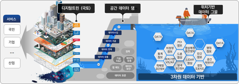
□ The Ministry of Land, Infrastructure, and Transport will be promoting the digital twin project, the core project of this year's Korean New Deal. It plans to invest a total of 4,368 billion won, focusing on digital twin technology development and high-precision spatial information production.
ㅇ The Ministry of Land, Infrastructure, and Transport confirmed the 6 National Spatial Data Policy Implementation Plan in accordance with the 18th National Spatial Data Policy Basic Plan* ('22-'21) on April 4 after deliberation by the National Spatial Information Committee (Chairman: Minister of MOLIT).
* (Vision) Realization of smart Korea that is livable and rich in spatial information convergence renaissance
ㅇ The National Geospatial Information Policy Implementation Plan is a statutory plan established annually by integrating the implementation plans of central ministries and local governments in accordance with the 「Framework Act on National Geospatial Information」 in order to secure the execution power of the basic plan and maintain policy consistency.
ㅇ In '21, it contains a plan for implementing spatial information policies for each institution, including plans to invest KRW 800 billion in a total of 4,368 projects, including the activation of spatial information* production and spatial information platforms in central ministries and local governments.
* Location information on natural or artificial objects existing in space, such as on the ground, underground, water, and underwater, and information necessary for spatial recognition and decision-making related thereto
** Promote KRW 57 billion for 2,986 projects by central government and KRW 743 billion for 1,382 projects by local governments
□ Digital Twin is one of the core projects of the Ministry of Land, Infrastructure, and Transport that is promoted as part of the pan-governmental Korean version of the New Deal project, which is taking a leap from a chasing economy to a leading economy.
ㅇ In particular, construction and utilization of spatial information, which is the major infrastructure of the 4th industry, is required for realization of the data economy, smart city, and autonomous vehicles.
ㅇ Accordingly, the implementation plan for 21 actively promotes the content of projects related to the 'digital twin', which is one of the key tasks of the 「Korean New Deal Comprehensive Plan (July 20.7)」,
ㅇ The promotion plans of the central ministries and local governments according to the four strategies* in the 6th Basic Plan for National Geospatial Information Policy ('18~'22) were presented by field.
* [Strategy 1] Producing value-creating geospatial information, [Strategy 2] Activating a geospatial information platform, [Strategy 3] Fostering a job-oriented geospatial information industry, [Strategy 4] Creating a policy environment for participation and win-win growth
□ The main contents of the '21 implementation plan are as follows.
◈ (Key business) Digital twin technology development and high-precision spatial information production and utilization: KRW 836 billion
ㅇ Expand investment in technology development related to'digital twin' for safe land and facility management and roles as a foundation for new industries such as autonomous driving and smart construction,
▪ Development of technology to provide realistic content convergence and mixed reality based on spatial information (40 billion won)
▪ Automated updating of integrated underground map and development of technology to support safety management at excavation sites (36 billion won)
▪ Digital twin-based fire disaster support integrated platform technology development (10 billion won)
ㅇ Focus on the production of high-precision spatial information such as precision maps, integrated underground space maps, and 3D topographic maps, which are basic information such as digital twins.
▪ Precision road map (160 billion won): Completion of highway construction by last year and construction of 11,570 km of general national highways and 6 km of autonomous driving pilot zones (100 local governments including Seoul City)
▪ Establishment of an integrated underground space map (134 billion won): Establish a 55D map that integrates underground facilities, structures, and ground in 33 cities including special cities and metropolitan cities until last year, and 3 cities such as Jeju and Yeosu this year.
▪ Construction of 3D topographic map (85 billion won): Construction of a three-dimensional three-dimensional topographic model of the entire country
▪ Digital twin national ISP and administrative utilization model local government pilot project (41 billion won): Establish a'digital twin system' that connects the ground and the underground with a 3D digital map, etc.
◈ (Plan by sector) Continuous investment in four areas of the basic plan: KRW 4 billion (including major projects)
ㅇ (Investment related to the production of value-creating spatial information: KRW 2,637 billion) Efficiently utilize new technologies for geospatial information and build high-quality spatial information necessary for safety accident prevention.
▪ Establishment of a national basic map in which various fields/technology and convergence/complex utilization function (MOLIT, 309 billion won)
▪ Large-scale digital topographic map (1/1000) production (MOLIT, KRW 100 billion) to support facility management in urban areas and prevent various safety accidents
▪ Building a heat map using drones (Seongnam, Gyeonggi, KRW 1.4 million), etc.
ㅇ (Investment related to activation of the geospatial information platform: KRW 1,337 billion) Promote the establishment of a platform to utilize the generated geospatial information for public service and administrative work.
▪ Operate a service platform (V World) for public and private use of 3D spatial information (MOLIT, KRW 14 billion)
▪ Establishing an integrated marine space management system that establishes and manages marine use zones through data-based evaluation of marine space characteristics and analysis of development potential (Ministry of Oceans and Fisheries, KRW 24 billion), etc.
ㅇ (Investment related to fostering the geospatial information industry and creating a policy environment: KRW 394 billion) Promote geospatial information construction and national support projects to support future new industries using advanced technology.
▪ Constructing a 3D spatial map applying extended reality (XR) technology to foster realistic services such as pedestrian roads and store locations and new industries (Seoul City, KRW 8.6 billion)
▪ Nurturing excellent talents in the field of spatial information convergence and convergence to respond to demand for high-tech technologies (MOLIT, KRW 17 billion), etc.
□Ministry of Land, Infrastructure, and Transport Nam Young-woo, National Territorial Information Policy Officer said, “With the establishment of the national geospatial information policy implementation plan in 2021, government policies to strengthen the competitiveness of the geospatial information industry are systematically promoted, and the foundation for fostering future new industries such as digital twins. It is expected that it will contribute to the preparation.”