


MOLIT, selected as a 'K-Drone System' demonstration operator
Demonstration projects to discover safe drone routes and expand the scope of use of drones such as blood delivery, disaster response, and facility safety management are being promoted.
The Ministry of Land, Infrastructure, and Transport announced on the 7th that it had selected 13 operators, including Korea Land Information Corporation, Korea Airports Corporation, and KT, for the 'K-Drone System' demonstration project.
'K-Drone System' is a drone traffic management system that approves drone flight plans, monitors location information, and prevents collisions with nearby flying objects.
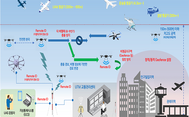
Drone use and drone traffic management concept
The demonstration project performer will seek ways to apply the technology developed as a K-Drone system R&D project to real life areas and demonstrate the operation of the transportation management system essential for business expansion.
This demonstration project is focused on areas that have high potential for commercialization and need to secure safety ▲City/airway (Korea Land Information Corporation) ▲Airport/special facilities (Korea Airports Corporation/KT) ▲Public (Korea Water Resources Corporation/Hancom Inspace) ) ▲Private (Systech) ▲Free competition (Marine drone technology) will be conducted in 5 fields.
In the airport and downtown areas, a slightly more advanced technology verification is carried out for the second time following last year, and for delivery, flight demonstration of delivering blood to a hospital in addition to the already commercialized maritime product delivery will be added.
In the field of city/airway discovery, the National Land Information Corporation is discovering a safe drone route with a drone traffic management function implemented for drone photography to acquire land information and to realize address-based delivery service.
In the field of airports and special facilities, we demonstrated the traffic management function for using drones when responding to disasters near national facilities (aircraft radio beacon facility) (Korea Airports Corporation) and demonstrated the method of interlocking with the traffic control system used by the army. (KT) do.
In the public sector, the project management model for the safe management of national important facilities (water system, dams, water intake facilities, etc.) was demonstrated (Korea Water Resources Corporation), and the cost for blood delivery between the Chungbuk branch of the Korean Red Cross and Osong Bestian Hospital (about 7.8 km) was carried out in the public sector. Demonstrate line-of-sight flight (Hancom Inspace).
The private sector is promoting demonstration (systech) that adds a drone traffic management function to the long-distance drone imaging business model for process management of highway construction sections.
The free competition field demonstrates drone traffic management procedures for the safe flight of various types of aircraft in the waters around Yeongdo, Busan (marine drone technology).
MOLIT expects to accelerate the commercialization of drone traffic management services, discovering 'done roads for specific purposes (delivery, filming, monitoring, etc.)
In addition, it is expected that it will be possible to prepare safety measures in response to the increase in drone traffic by accumulating empirical data on local security and safety through the special facilities added this year.
Na Jinhang, MOLIT’s future drone traffic manager, said, “A drone traffic management system is essential for multiple drones to fly long distances. said.