– Seongnam-si, Hongcheon-gun, and Jincheon-gun were selected for the leading project of local governments utilizing spatial information –
□ Ministry of Land, Infrastructure, and Transport announced on February 25th the results of the 「Local Geospatial Information Model Leading Project (hereinafter referred to as Model Leading Project)」 held from November 23th to December 2rd of last year to spread 「Digital Twin National Land」.
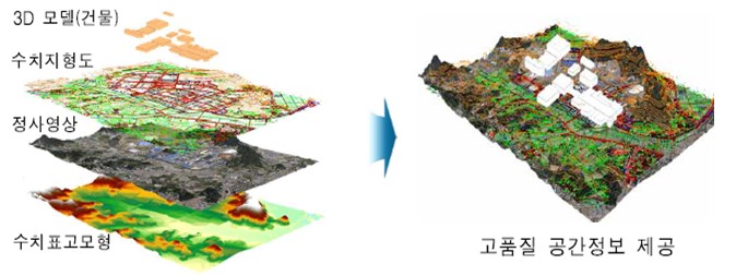
ㅇ Digital twin is a technology that embodies and simulates real spatial information in a virtual world as a major task of the Korean version of the New Deal and predicts the result. It is used to support solving urban and regional problems through data linkage analysis to advance national and urban administration. Is attracting attention as an essential element of
ㅇ Accordingly, the Ministry of Land, Infrastructure, and Transport conspired for the first model geospatial information initiative for local governments across the country for the first time this year to discover excellent business models such as digital twin use cases and spread them across the country.
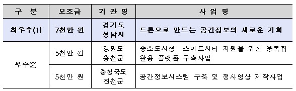
□ The best project was selected as a'new opportunity for spatial information made with drones' in Seongnam-si, Gyeonggi-do, and Hongcheon-gun, Gangwon-do and Jincheon-gun, Chungcheongbuk-do, respectively, were selected as excellent projects.
<Results of selection of model leading spatial information project in 2021>
ㅇ The'New Opportunity of Spatial Information Made with Drones' of Seongnam City, which was selected as the best project, is a project that is used to select and analyze the location of planting and forest formation for carbon neutrality by building a heat map using drones.
– Along with differentiated contents, it received a high score for being able to provide citizens' tangible spatial information services such as welfare support in preparation for heat waves.
ㅇ The excellent project,'Convergence Utilization Platform Construction Project for Small and Medium-sized Smart City Support' (Hongcheon-gun, Gangwon-do) is a business that establishes the foundation of a digital twin convergence platform by applying 3D three-dimensional model automatic production technology.
-The possibility of utilization and spread was outstanding by introducing projects that reflect the characteristics of small and medium-sized cities such as response to the increase in vacant homes, analysis of the location of the tourism industry, and disaster prevention for livestock and agriculture.
ㅇ'Spatial information integrated system construction and orthogonal image production project' (Jincheon-gun, Chungcheongbuk-do) is a business that establishes a system that integrates and manages various spatial information possessed by Jincheon-gun and produces orthogonal images* for major changing areas.
* Video produced continuously by removing the topographical undulations of aerial photographs and satellite images
-Various fields of application such as land survey, public construction, river management, and forest protection, as well as urban survey and cadastral work, are suggested, and it is expected to establish a standard process for producing orthogonal images using drones.
□ We plan to support 21 million won and 7 million won each for the best project selected as a model leading project for spatial information in 5 as a subsidy for the geospatial information project this year.
ㅇ In addition, we plan to introduce the model leading project through the Smart Land Expo ('21.7.21.~23, COEX) and workshops in charge of spatial information policy of local governments so that they can serve as a model for other local governments.
□ Ministry of Land, Infrastructure, and Transport Nam Yeong-woo, Director of National Territorial Information Policy, emphasized that “spatial information is the core infrastructure of digital twins, and in particular, the use of spatial information is essential for the development of a convergence platform that considers the characteristics of cities.”
ㅇ “We plan to do our best to actively discover exemplary projects such as digital twin use cases and spread them across the country.”
<New opportunity for spatial information created by drones (Seongnam-si, Gyeonggi-do)>
Establish a thermal temperature (high temperature, low temperature) map (30 km2) with a drone, and make policy decisions through GIS analysis with spatial information such as old buildings and population distribution.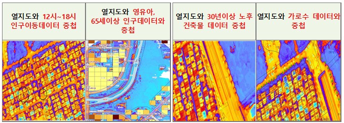
<Convergence utilization platform construction project to support small and medium-sized smart cities (Hongcheon-gun, Gangwon-do)>
Utilization of digital twin and drone: Automatic 3D model production and digital twin construction by applying hybrid sensors (vertical image, tilt image, aerial LiDAR integration)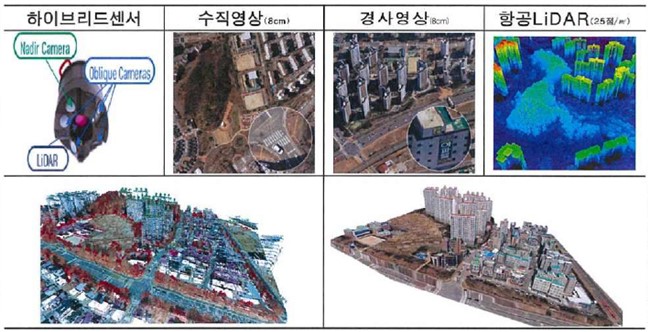
<Establishment of integrated spatial information system and production of orthodox images (Jincheon-gun, Chungcheongbuk-do)>
(Applied new technology) Drone utilization: Improved orthoimage accuracy with a drone equipped with RTK function, and secured accuracy and quality by using S/W (PIX4D) for orthoimage production (resolution 4cm level)