


– June 6 National Geographic Information Institute-Gyeongsangbuk-do-Gyeongsangbuk-do National Police Agency business agreement signed
– Utilization of geospatial information in the field of disaster management and smart city to realize 'Gyeongbuk Digital Transformation'
□ Ministry of Land, Infrastructure, and Transport The National Geographic Information Institute (Director Cho Woo-seok) met with Gyeongsangbuk-do (Provincial Governor Lee Chul-woo) and Gyeongsangbuk-do National Police Agency (Director Choi Joo-won) at the Gyeongbuk Provincial Office at 6:8 pm on June 4. efficiencydisaster management와 Expansion of use of national spatial information를 signed a business agreement forSaid.
o This agreement Improving the efficiency of disaster management using spatial informationand, smartExpansion of various services of spatial information in the city fieldto Gyeongbuk of the digital transformation strengthen competitivenesswas prepared to
ㅇ Through this agreement, ▲ utilization of disaster areas such as national satellite imagery and emergency spatial information, ▲ establishment and spread of disaster management geospatial information utilization models, and feedback of outcomes, ▲ information sharing and mutual cooperation in the smart city sector using spatial information, and ▲ other Collaborative tasks will be discovered and a regular exchange system will be established.
□ Governor Lee Chul-woo of Gyeongsangbuk-do said, “This agreement Transportation as well as disaster area utilization, welfare, A catalyst for the utilization of spatial information in all areas of smart city, such as the environment“Through cooperation and consultation with the National Geographic Information Institute, virtual models and 3D map utilization platforms, etc. Discovery of various geospatial information cooperation projects in the field of smart cityby digital Efforts to take Gyeongbuk to the next levelwill do,” he said.
□ Director Cho Woo-seok of the National Geographic Information Institute said, “The disaster management field is an area where high-quality spatial information produced by the National Geographic Information Institute can be most valuable for the safety of the people. A space for disaster management that supports scientific decision-making in a timely mannercontinue to provide informationand produced by the National Geographic Information Institute. Spatial InformationWe will do our best to become a growth engine for local governments.”he said.
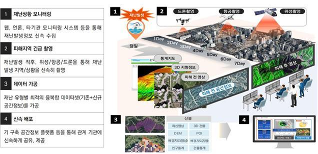
<Outline of emergency geospatial information service>

<Overview of emergency geospatial data>