


– National satellite map web service provided from the 14th... The functionality of the national information platform has also been significantly improved.
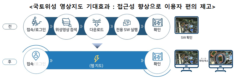
□Ministry of Land, Infrastructure, and Transport National Geographic Information Institute(Director Jo Woo-seok) View of the entire Korean PeninsulaWithout downloading the latest satellite orthoimagery* containing Check directly on the webThat can be National satellite-based video map(National Satellite Map) from February 2th offerdo.
* Compared to images taken from satellites, the location accuracy has increased (tens of meters → within 2m) and the resolution has improved (2m → 0.5m), so the image has clear and accurate location information. The size is about 10GB, so it takes a long time to download. There is discomfort
ㅇ Along with this, National satellite information related services Comprehensive in one placeso that it can be used as existing landInformation platform service functions have also been significantly improved.It was.
□ Through the newly prepared national satellite map web service, regularlyto country where it was filmedUsing satellite imagesThe latest satellite map Delivered quicklyI was able to do it.
ㅇ Precisely updated on a yearly basis based on aerial photos National land information platform and private search portal Unlike video guidance services,, It is now possible to check the current state of affairs, providing citizens with Provide the latest informationIt is expected to be possible.
□ Additionally, to improve the usability of national satellite information, Conditional search, Video comparison, Manual provided Etc By improving the functionality of the national information platform Increased user convenience.
ㅇ Conditions such as search by administrative district and designation of area of interest were added to make it easier to search national satellite image product information. Enhanced search functiondo, 'National satellite image comparison’, national satellite 'shooting plan’, 'Notification status', 'Latest video from our neighborhoodA total of 8 new contents, including ', will be released.
ㅇ In particular, 'Latest video from our neighborhood' The content is By adding a function to search national satellite images and aerial images for user-specified areas of interest, the National Geographic Information Institute has Easily provides users with the most up-to-date video information.
□ Cho Woo-seok, Director of National Geographic Information Institutesilver "This service improvement is People watch satellite images An opportunity to make it easier to access and increase friendlinessIt will be like a national satellite map. Continuing to expand services that citizens can experience“We plan to do it,” he said.